Tra i vari consigli che in parte vi abbiamo già dato e che ci sentiamo ancora di darvi, c’è anche quello di imparare a usare bene il vostro navigatore, sia quello interiore, il vostro senso dell’orientamento, che quello che avete sul manubrio. Che si tratti di smartphone o Garmin. Il vostro Garmin, unito alla capacità di saperlo usare al meglio, vi consentirà di non aggiungere chilometri inutili, dovuti ad errori di percorso.
La regola fondamentale è: dovete sempre sapere dove siete e dove volete o dovete andare. E non fate affidamento sulle indicazioni che potreste ottenere strada facendo. Il più delle volte vi indirizzeranno sulle strade principali. Piene di traffico.
Il Garmin sul manubrio

follow me
Guardate con regolarità il display del vostro strumento di navigazione, accertatevi con elevata frequenza di essere “in traccia”. Nei tratti dove potrebbe risultare più facile sbagliare strada troverete indicazioni adesive rosse e gialle, applicate a guard-rail o ai pali della segnaletica stradale (immagine a destra). Siate vigili sul percorso, attenti ai bivi, in genere il percorso da seguire è su strade minori, se vi trovate su strade con traffico guardate il vs display per essere sicuri di non essere finiti fuori traccia.
Definite una vostra ideale scaletta dei tempi, sulla media che pensate di tenere lungo tutto il percorso (vedi la tabella tempi pubblicata nel post Il ritmo della Chase the Sun) e regolatevi anche con questi parametri. Abituatevi a farlo anche durante i vostri allenamenti. Quello dalla Chase the Sun sarà un giorno lungo. In tutti i sensi. Spezzatelo in più frazioni. La prima, volerà. La seconda sarà leggera. Quella successiva si sentirà di più. L’ultima è sicuramente la peggiore, ma consolatorio sarà il pensare che manca poco alla fine. Questo potrà aiutarvi e sostenervi. L’importante è sapere sempre dove vi trovate, in quale delle frazioni in cui avete diviso il percorso e che cosa potete aspettarvi dal vostro corpo e dalla vostra mente.
Ricordatevi di portare batterie di scorta o un power-bank portatile nel caso usiate strumenti di navigazione con batterie al litio. Difficilmente la batteria interna sarà sufficientemente a far funzionare lo strumento per tutta la durata della vostra prestazione.
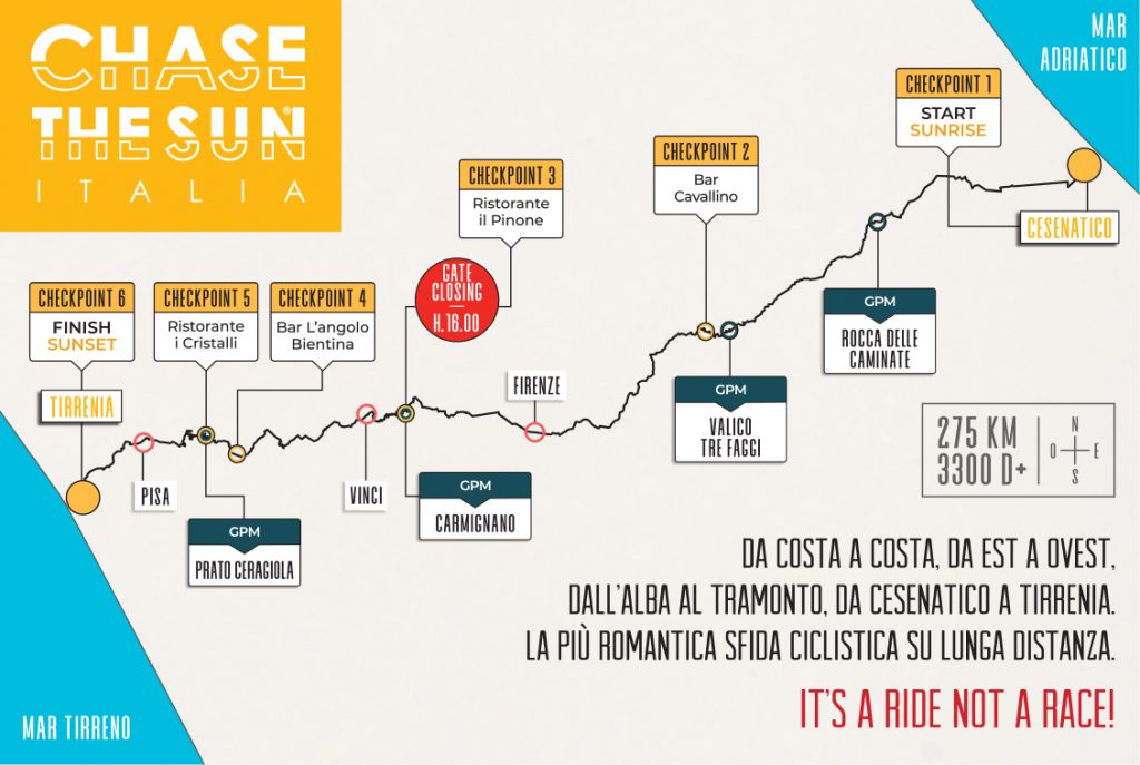
Studiate attentamente il road-book e la mappa del percorso
Suggeriamo comunque a tutti, con o senza navigatore satellitare, di scaricare il roadbook e dedicare più di qualche minuto a studiarlo bene. Abbiamo realizzato una mappa al 100.000 divisa in due sezioni, che potete scaricare. La traccia GPX sarà disponibile dal 22 maggio. NOTA BENE: suggeriamo a chi non fosse equipaggiato con Garmin o analogo navigatore di portarsi la cartina, o il road book, che può essere caricato in formato PDF sullo smartphone. Oppure stare in un gruppo guidato dai Ride Pacer Turbolenti, o un gruppo in cui ci sia almeno un navigatore. Il classsico roadbook cartaceo (quello che potete scaricare da qui) con indicazione delle svolte chilometro per chilometro è sempre valido, attrezzatevi con la cara, vecchia busta di plastica posizionata sul manubrio per averlo sotto gli occhi, senza continue soste di consultazione. Ricordatevi anche che, in caso di eventuali errori e allungamenti di percorso, le distanze chilometriche indicate risultano “sballate” rispetto a quanto riportato sul vostro contachilometri.
Scarica la mappa al 100.000 Cesenatico-Firenze (7pagg)
Scarica la mappa al 100.000 Firenze-Tirrenia (6pagg)
Quest’anno Chase the Sun Italia celebra il quinto centenario dalla morte di Leonardo. Molti i luoghi lungo la strada che hanno legami col geniale, curioso, maestro di Vinci. Dal luogo di partenza, il Porto Canale di Cesenatico a Firenze, a Vinci, con passaggio dalla casa natale. Arrigo Vecchioni, per Cyclist, ha firmato il pezzo “Sulla strada di Leonardo“.
Hai già letto gli altri nostri consigli per affrontare al meglio la tua Chase the Sun?
8 gennaio – suggerimenti per affrontare la distanza,
21 gennaio – l’importanza delle giuste soste,
5 febbraio – i tre fondamentali di percorso,
4 marzo – consigli per chi affronterà la sfida in staffetta
4 aprile – indicazioni sui tempi e le andature
E poi i Luoghi della Chase the Sun nell’interpretazione di Giacomo Pellizzari o una giornata inseguendo il sole nello stile inconfondibile di Marco Pastonesi.
Among the various suggestions we’ve so far given, we feel we can still give you more. There is also that of learning how to use your navigator to its best advantage, not only your own one: i.e., your innate sense of direction but also the one you can attach to your handlebars, whether it’s a smart phone or a Garmin GPS device. Your Garmin, combined with the ability to know how to use it to the fullest, will allow you to avoid adding unnecessary kilometres to your route.
The basic rule is: you always have to know where you are and where you want or need to go. And don’t rely on the indications you could find along the way. Most of the time they will direct you to the busy main roads, full of traffic.
A Garmin GPS device on your bike’s handlebars
Look regularly at your navigation instrument’s display screen, and keep making sure you are “on track”. In areas where it could be easy to go the wrong way, you’ll find red and yellow adhesive signs applied to guard rails or road signs (image on the right). Always be alert on the route and pay careful attention at crossroads. Generally, the route goes along minor roads but if you ever find yourself on roads with a lot of traffic, glance down at the display screen to be sure you’re not “off track”.
Define your average ideal time schedule on the device you plan to use along the way (see the times shown in the post Chase the Sun rhythm) and adjust your timing according to these guidelines. Try to get used to doing this during your training workouts. The Chase the Sun event will be a long day in all senses. We suggest you break it into several parts: The first one will fly; the second will be fairly light; the next one will be more strenuous; the last one will surely be the most strenuous, but it will be comforting to know that you’re close to the end. This will both help and support you.
The important thing is to always know where you are, in which part you have divided up the route and what you can expect from both your body and your mind.
Remember to bring spare batteries or a power bank if you use navigation instruments with lithium batteries. The device battery will scarcely be enough to operate the instrument for the duration of your performance.
Carefully study the road book and the route map
We suggest you download the road book anyway, whether you use a satellite navigator or not, and then spend more than a few minutes studying it well. We have created a 1:100.000 map divided into two sections, which can be downloaded.
The GPX track made available on 22 May 2019.
PLEASE NOTE: We suggest to those of you who are not equipped with a Garmin GPS device or some other similar navigator to bring your own map or the road book, which can be uploaded in PDF format onto your smart phone. You may, however, prefer to stay in a group led by Turbolenti Ride Pacers or a group in which there is at least one navigator instrument present.
The classic road book in paper format (the one you can download here) with an indication of the distances kilometre by kilometre is, nevertheless, useful. Place it inside a protective plastic wallet where it is easy to see on the handlebars so as to avoid having to continuously stop to look at it. Remember also that, in the event of any errors and lengthening of the route, the distances indicated in kilometres will be different to those compared with your kilometre counter or odometer.
Download the 1:100.000 map of Cesenatico-Florence (7 pages)
Download the 1:100.000 map of Florence-Tirrenia (6 pages)
This year’s Chase the Sun Italy celebrates the fifth centenary of Leonardo da Vinci’s death. There are many places along the route that have links with the genial, ever-curious master from the village of Vinci, from the departure point at Porto Canale di Cesenatico to Florence, then on Vinci passing by his birthplace. Arrigo Vecchioni, writing for “Cyclist”, called this route “On the road of Leonardo“.